.


HORSE CREEK PARK TRAILS - PETE'S BRANCH FALLS
     

April 13th, 2008 - I've been spending a lot of time lately exploring the sites in the National Forest off of Highway 107 toward Greenville, Tennessee.  Today I did the same by checking out a few of the trails in the Horse Creek Park area...  ultimately finding Pete's Branch Falls.


I parked the Jeep at the end of the asphalt road in Horse Creek Park.  And even though the asphalt ends here, the road/trail continues by gravel.  But, ONLY attempt to travel it with a high clearance, 4-wheel drive vehicle as this is a pretty rough road.  Since the weather was dreary, I was tempted to take the Jeep on up this road to get closer to the falls, but it wasn't raining when I arrived so I decided to park and do it all on foot.  I'm glad I did because the rain held off all day except for a few slight showers.     


20080413_34.JPG (436614 bytes)


20080413_28.JPG (1162824 bytes)

Sign Pointing the Way to the Hiking Trails

  Sign for Pete's Branch Trail
     
20080413_7.JPG (1262307 bytes)   20080413_17.JPG (1160655 bytes)
45' Pete's Branch Falls   The Base of the Falls
     

I briefly explored some side trails before ending up on the Pete's Branch Trail (CNF #12), and I eventually found Pete's Branch Falls (see the detailed hiking directions below).  This is a ~45' waterfall that normally has little flow except in really wet conditions, but I found them to be very scenic nonetheless.  I took some photos and ate a snack before making my descent back to the Jeep.  On the return I found a couple of other smaller waterfalls that I photographed.  There was also a pretty field of wildflowers on the Pete's Branch Trail that was just beginning to bloom.         

     
20080413_20.JPG (1197302 bytes)   20080413_23.JPG (455793 bytes)
Me at the Base of Pete's Branch Falls   Another View
     

I also ran into a lot of nice people today on the multi-use road/trail.  I talked to two very nice guys on mountain bikes early in my hike.  I also saw five people on horseback, and then I talked to another group of nice folks in a 4x4 club (who were mostly in Jeeps).  They had taken the forest road all the way to the top of the mountain near the Appalachian Trail... something I'd like to do with my family soon.   

     
20080413_25.JPG (215585 bytes)   20080413_31.JPG (957449 bytes)
Vinca in Bloom   Small 4' Waterfall on Pete's Branch
     
20080413_33.JPG (826392 bytes)   20080413_37.JPG (997663 bytes)
Another View of the Small Waterfall   More Cascades Located Downstream on Horse Creek
     

Overall this is a wonderful and scenic hike.  With my exploration of the other trails, I hiked a total of 5.2 miles. But I think if you go straight from the asphalt parking lot to the falls it's about 4.2 miles round-trip.  Again, a lot of distance could be cut off by taking the forest road in with a 4x4 vehicle, but I enjoyed it better by walking.  See detailed directions below for hiking directly to the falls.    


Total Miles Hiked:  5.2 


Getting There:  


Driving - From Johnson City, take I-26 to the Erwin/Jonesborough exit (#37). At the end of the ramp turn right and take State Rt. 81/107 for 6.5 miles.  Stay on Rt. 107 by turning left and continue for 13.2 miles. Turn left onto Horse Creek Park Road (you'll also see the Cherokee National Forest sign).  Follow this road for approximately three miles while following the signs for the park. Drive all the way through the park to the parking area at the end of the paved road.    


Trails - To get to the falls from the asphalt parking area, set out on the graveled forest road and travel 0.8 miles to a wide junction in the road.  You will have crossed the stream twice at this point.  Continue on the road to the left, immediately crossing the stream again (for the 3rd time).  Go another ~.2 miles, fording the stream for the 4th time, and then you will see a brown sign designating the trails (1st photo show above).  Take a right at the sign and continue for .5 miles past a parking area and across the small stream.  You will soon run into a junction in the trail with a post.  Take a left at this post on the blue-blaze trail.  You will soon 
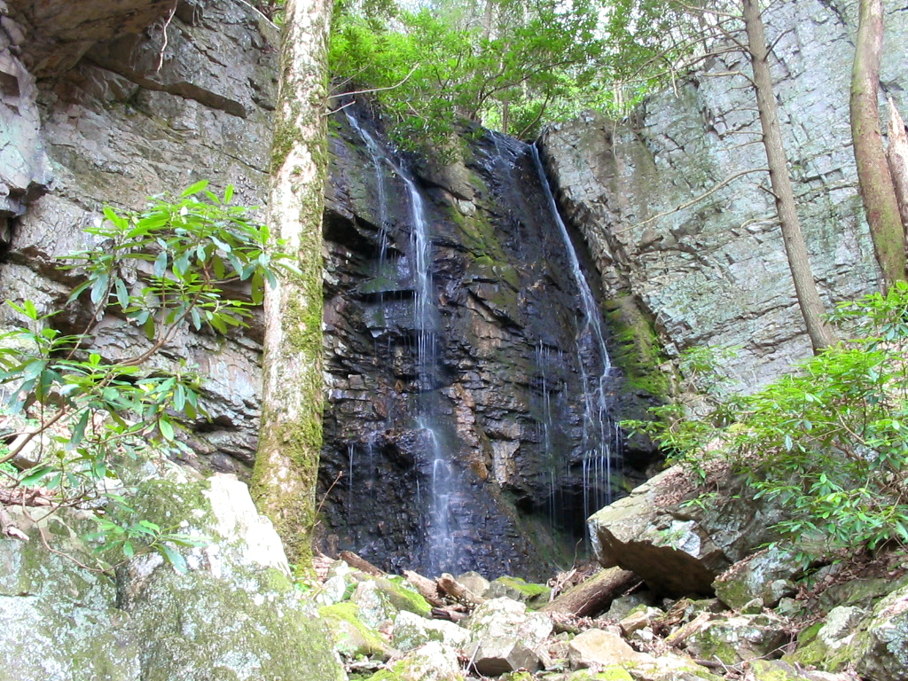
see the sign for "Pete's Branch Trail" (second photo shown above).  Follow this well-marked blue-blaze trail for .6 miles to it's terminus at the falls. 


Expect to get wet at least up to your ankles as the first four stream crossings on Horse Creek are wide and difficult to hop from rock to rock.  On Pete's Branch there's also 4 or 5 more smaller stream crossings.  There's not that much elevation gain in the entire hike, but the stream crossings may classify it as a moderate to difficult hike, especially for children.            

  HOME  
  TRAIL LOGS  
  THE A.T.  
  SUMMITS  
  WATERFALLS  
  TRAIL SYSTEMS  
  BIOGRAPHY  
  MY GEAR  
  GOALS  
  CURRENT PROJECTS  
  OTHER ADVENTURES  
  OTHER INTERESTS  
  DOWNLOADS  
  RESOURCES  
  CONTACT BILL